![](/images/other/stat-length.png)
![Randonnée Marche La Ferté-Saint-Aubin - La Ferté-Saint -Aubin PR du Mazuray - Photo](https://media.geolcdn.com/t/1900/400/ext.pjpeg?maxdim=2&url=https%3A%2F%2Fstatic1.geolcdn.com%2Fsiteimages%2Fupload%2Ffiles%2F1553511878bg_sport_marche.png)
La Ferté-Saint -Aubin PR du Mazuray
boissay
Utilisateur
![Longueur](/images/other/stat-length.png)
Longueur
12,5 km
![Altitude max](https://static1.geolcdn.com/siteimages/upload/files/1508320355ic_sort_altitude_max_24dp.png)
Altitude max
146 m
![Dénivelé positif](https://static1.geolcdn.com/siteimages/upload/files/1508320355ic_sort_den_pos_24dp.png)
Dénivelé positif
99 m
![Km-Effort](/images/other/stat-length.png)
Km-Effort
13,9 km
![Altitude min](https://static1.geolcdn.com/siteimages/upload/files/1508320355ic_sort_altitude_min_24dp.png)
Altitude min
102 m
![Dénivelé négatif](https://static1.geolcdn.com/siteimages/upload/files/1508320355ic_sort_den_neg_24dp.png)
Dénivelé négatif
99 m
![Boucle](https://static1.geolcdn.com/siteimages/upload/files/16400158638029165_repeat_loop_refresh_sync_direction_icon.png)
Boucle
Oui
Date de création :
2014-12-10 00:00:00.0
Dernière modification :
2014-12-10 00:00:00.0
![Marche](https://static1.geolcdn.com/sitytour/trail-icons/101.png)
3h03
Difficulté : Facile
![Scannez ce code QR pour ouvrir la randonnée dans l'application SityTrail](https://capi.geolives.com/qq0zvz2zws4bq2lad0pu/sitytour/trails/273485/qr.png?size=200)
Application GPS de randonnée GRATUITE
À propos
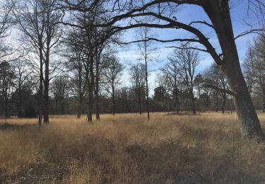
Randonnée Marche de 12,5 km à découvrir à Centre-Val de Loire, Loiret, La Ferté-Saint-Aubin. Cette randonnée est proposée par boissay.
Description
Circuit permettant de profiter de beaux paysages boisés solognots et des bords du Cosson.
Seul bémol, le passage long de 2 km sur une petite route bitumée en milieu de parcours.
Localisation
Pays :
France
Région :
Centre-Val de Loire
Département/Province :
Loiret
Commune :
La Ferté-Saint-Aubin
Localité :
Unknown
Départ:(Dec)
Départ:(UTM)
420486 ; 5286487 (31T) N.
Commentaires
Randonnées à proximité
![Randonnée V.T.T. La Ferté-Saint-Aubin - La Ferté St Anbin - Vouzon - Photo](https://media.geolcdn.com/t/375/260/ext.jpg?maxdim=2&url=https%3A%2F%2Fservices.sitytrail.com%2FGeolivesWS%2FDownloadMedia.ashx%3FTrailID%3D103899%26Media%3D6725_3.jpg)
![V.T.T. V.T.T.](https://static1.geolcdn.com/sitytour/trail-icons/202.png)
La Ferté St Anbin - Vouzon
V.T.T.
Moyen
La Ferté-Saint-Aubin,
Centre-Val de Loire,
Loiret,
France
![](/images/other/stat-length.png)
37 km | 40 km-effort
3h 0min
![](https://static1.geolcdn.com/siteimages/upload/files/16400158638029165_repeat_loop_refresh_sync_direction_icon.png)
Oui
![Randonnée V.T.T. La Ferté-Saint-Aubin - La ferté - Yvoy le marron - Photo](https://media.geolcdn.com/t/375/260/ext.jpg?maxdim=2&url=https%3A%2F%2Fservices.sitytrail.com%2FGeolivesWS%2FDownloadMedia.ashx%3FTrailID%3D722694%26Media%3D20170329165819.jpg)
![V.T.T. V.T.T.](https://static1.geolcdn.com/sitytour/trail-icons/202.png)
La ferté - Yvoy le marron
V.T.T.
Facile
La Ferté-Saint-Aubin,
Centre-Val de Loire,
Loiret,
France
![](/images/other/stat-length.png)
23 km | 26 km-effort
2h 23min
![](https://static1.geolcdn.com/siteimages/upload/files/16400158638029165_repeat_loop_refresh_sync_direction_icon.png)
Oui
![Randonnée Marche La Ferté-Saint-Aubin - LA FERTE ST AUBIN - Photo](https://media.geolcdn.com/t/375/260/ext.jpg?maxdim=2&url=https%3A%2F%2Fstatic1.geolcdn.com%2Fsiteimages%2Fupload%2Ffiles%2F1553511878bg_sport_marche.png)
![Marche Marche](https://static1.geolcdn.com/sitytour/trail-icons/101.png)
LA FERTE ST AUBIN
Marche
Très facile
La Ferté-Saint-Aubin,
Centre-Val de Loire,
Loiret,
France
![](/images/other/stat-length.png)
7,5 km | 8,3 km-effort
1h 50min
![](https://static1.geolcdn.com/siteimages/upload/files/16400158638029165_repeat_loop_refresh_sync_direction_icon.png)
Oui
![Randonnée V.T.C. La Ferté-Saint-Aubin - De la Ferté St aubin à Mézières lez Cléry - Photo](https://media.geolcdn.com/t/375/260/ext.jpg?maxdim=2&url=https%3A%2F%2Fstatic1.geolcdn.com%2Fsiteimages%2Fupload%2Ffiles%2F1524743154velo.jpg)
![V.T.C. V.T.C.](https://static1.geolcdn.com/sitytour/trail-icons/203.png)
De la Ferté St aubin à Mézières lez Cléry
V.T.C.
Facile
La Ferté-Saint-Aubin,
Centre-Val de Loire,
Loiret,
France
![](/images/other/stat-length.png)
19,1 km | 21 km-effort
2h 3min
![](https://static1.geolcdn.com/siteimages/upload/files/16400158638029165_repeat_loop_refresh_sync_direction_icon.png)
Non
![Randonnée V.T.T. La Ferté-Saint-Aubin - VTT 36km La Ferté Chaumont Yvoy - Photo](https://media.geolcdn.com/t/375/260/ext.jpg?maxdim=2&url=https%3A%2F%2Fstatic1.geolcdn.com%2Fsiteimages%2Fupload%2Ffiles%2F1524743154velo.jpg)
![V.T.T. V.T.T.](https://static1.geolcdn.com/sitytour/trail-icons/202.png)
VTT 36km La Ferté Chaumont Yvoy
V.T.T.
Très facile
La Ferté-Saint-Aubin,
Centre-Val de Loire,
Loiret,
France
![](/images/other/stat-length.png)
36 km | 40 km-effort
2h 49min
![](https://static1.geolcdn.com/siteimages/upload/files/16400158638029165_repeat_loop_refresh_sync_direction_icon.png)
Oui
![Randonnée V.T.T. La Ferté-Saint-Aubin - 2010-09-19 LFSA - Lamothe Beuvron - Photo](https://media.geolcdn.com/t/375/260/ext.jpg?maxdim=2&url=https%3A%2F%2Fstatic1.geolcdn.com%2Fsiteimages%2Fupload%2Ffiles%2F1524743154velo.jpg)
![V.T.T. V.T.T.](https://static1.geolcdn.com/sitytour/trail-icons/202.png)
2010-09-19 LFSA - Lamothe Beuvron
V.T.T.
Très facile
La Ferté-Saint-Aubin,
Centre-Val de Loire,
Loiret,
France
![](/images/other/stat-length.png)
51 km | 57 km-effort
Inconnu
![](https://static1.geolcdn.com/siteimages/upload/files/16400158638029165_repeat_loop_refresh_sync_direction_icon.png)
Oui
![Randonnée A pied La Ferté-Saint-Aubin - Garmin essais 1 du 20 - Photo](https://media.geolcdn.com/t/375/260/ext.jpg?maxdim=2&url=https%3A%2F%2Fstatic1.geolcdn.com%2Fsiteimages%2Fupload%2Ffiles%2F1545311037marcheuse_200dpi.jpg)
![A pied A pied](https://static1.geolcdn.com/sitytour/trail-icons/100.png)
Garmin essais 1 du 20
A pied
Facile
La Ferté-Saint-Aubin,
Centre-Val de Loire,
Loiret,
France
![](/images/other/stat-length.png)
6,2 km | 6,9 km-effort
1h 34min
![](https://static1.geolcdn.com/siteimages/upload/files/16400158638029165_repeat_loop_refresh_sync_direction_icon.png)
Oui
![Randonnée Marche La Ferté-Saint-Aubin - venelles 2 - Photo](https://media.geolcdn.com/t/375/260/ext.jpg?maxdim=2&url=https%3A%2F%2Fstatic1.geolcdn.com%2Fsiteimages%2Fupload%2Ffiles%2F1553511878bg_sport_marche.png)
![Marche Marche](https://static1.geolcdn.com/sitytour/trail-icons/101.png)
venelles 2
Marche
Très facile
La Ferté-Saint-Aubin,
Centre-Val de Loire,
Loiret,
France
![](/images/other/stat-length.png)
5,3 km | 6 km-effort
1h 12min
![](https://static1.geolcdn.com/siteimages/upload/files/16400158638029165_repeat_loop_refresh_sync_direction_icon.png)
Non
![Randonnée Marche La Ferté-Saint-Aubin - venelles la ferte saint aubin - Photo](https://media.geolcdn.com/t/375/260/ext.jpg?maxdim=2&url=https%3A%2F%2Fstatic1.geolcdn.com%2Fsiteimages%2Fupload%2Ffiles%2F1553511878bg_sport_marche.png)
![Marche Marche](https://static1.geolcdn.com/sitytour/trail-icons/101.png)
venelles la ferte saint aubin
Marche
Très facile
La Ferté-Saint-Aubin,
Centre-Val de Loire,
Loiret,
France
![](/images/other/stat-length.png)
11 km | 12,2 km-effort
2h 47min
![](https://static1.geolcdn.com/siteimages/upload/files/16400158638029165_repeat_loop_refresh_sync_direction_icon.png)
Oui